


ANNUAL WEATHER FORECAST 2020 – (VEDIC METEOROLOGY)
(FOR THE INDIAN SUB-CONTINENT)
Article by: RAMACHANDRAN, Astro-Meteorologist.
My 2019 Annual weather Forecast was way off the mark from the last week of July, 2019. My forecast of SEVERE DRAUGHT failed miserably though peak rainfalls occurred as per my warning dates. I take full responsibility for the lapses and offer my “SINCERE APOLOGIES” to all. The weather patterns during 2019 have taught lessons the hard way and I am sure that it will help me in research and improve my future forecasts.
MAIN POINTS:
(1-A) From 2019 December second week beginning till the third week of January, 2020 – the ‘Winter’ will be severe over northwest India and Himalayan region. But the plains and the southern peninsula will experience moderate winter & dry weather only. Severe blizzards with heavy to very heavy snowfall, Avalanches and icy rainfall are forecast during the above period.
(1-B) Between the last week of January and the end of February, 2020 Powerful “Negative Indian Ocean Dipole” will be active. Blizzards, with massive snowfall, icy rainfall in the Himalayan region are forecast during the above period, Avalanches, landslides, Killer Lightning and severe flooding will cause fatalities and upset normal life. West & Northwest Punjab and North & West Haryana will also suffer. Northeastern states (Icy rainfall), south Tamilnadu, Kerala and southwest Karnataka will experience incessant rainfall resulting in flooding.
(2) From the beginning of March, 2020 till the first week of May, 2020 “Strong Positive Indian Ocean Dipole” will be active. During this period rapid mercurial changes in weather will result in “Progressively Very Hot conditions with Record High Temperatures”. Extra tropical cyclone systems, Tropical cyclones, Thunderstorms, Tornadoes and ‘KILLER LIGHTNING’ will be active during this period. West and Northwest states and the Himalayan region will experience “Heavy to Very Heavy” rainfall. Catastrophic damages to life and property due to severe flooding, landslides will upset normal life. High altitude hill regions (Both in the North & south) are also warned about similar weather conditions during the above period. Southern peninsular India will remain hot and dry with occasional thunderstorms and Convective precipitation at isolated places.
(3) Moderate Pre-Monsoon rainfall followed by early setting of SOUTH-WEST MONSOON -2020 is forecast between the second week of May and the first week of June, 2020. The Best Rainfall benefits of 2020 Southwest Monsoon will be gained between the first week of May, 2020 and the second week of August, 2020. Two distinctly different weather patterns are forecast (I) From the first week of May till the first week of June, 2020 more widespread rainfall is forecast. (II)Squally winds with Thunderstorms, Induced Cyclonic Circulation, Tropical Cyclones and Convective precipitation are forecast from the second week of June till the second week of August, 2020. Heavy to Very Heavy incessant rainfall during the above period will cause ‘SEVERE FLOODING’. Localised storms, flooding and KILLER LIGHTNING will cause devastations and fatalities during the above period. “From the third week of July till the third week of October, 2020 there will be distinct difference in weather patterns between the first & second fortnight of the months. The first fortnight will experience ‘BETTER’ wet conditions than the second fortnight”.
(4) From the third week of July, 2020 conditions will indicate emergence of “POWERFUL ELNINO”. From the third week of August till the last week of October, 2020 “VERY POWERFUL ELNINO” will be “ACTIVE”. During the above period it will be ‘VERY HOT & DRY’. High activities of Tornadoes, Tropical Cyclones, Trough in Easterlies, Thunderstorms with squally winds & KILLER LIGHTNING and Convective precipitation are forecast during the above period. Isolated places will suffer flooding and damages due to the above conditions. In view of these conditions I forecast “2020 SOUTHWEST MONSOON to be DEFICIT & SCANTY”. 2020 will be registering VERY POOR MONSOON FAILURE comparable to 2019 MONSOON.
(5) 2020 will have “EXCELLENT NORTHEAST MONSOON”. From the last week of October, 2020 till the second week of January, 2021 “Widespread Incessant Rainfall” is forecast. During the above period due to Cyclonic circulations, Tropical Cyclone, thunderstorms with KILLER LIGHTNING will cause FLOODING, LANDSLIDES and DEVASTATIONS upsetting normal life. Also during the above period “More Cyclonic activities are forecast in the Arabian sea”.
DETAILED FORECAST:
(1-A) From 2019 December second week beginning till the third week of January, 2020 – the ‘Winter’ will be severe over northwest India and Himalayan region. But the plains and the southern peninsula will experience moderate winter & dry weather only. Severe blizzards with heavy to very heavy snowfall, Avalanches and icy rainfall are forecast during the above period.
Important dates for disaster preventive measures:
a) Between 12th December, 2019 and 21st December, 2019 Powerful Blizzards with Heavy to Heavy Snowfall/Icy rainfall triggering devastating ‘Avalanche’ are forecast. Conditions during the above period will be similar to the effects of POLAR VORTEX. Kashmir, Jammu, Ladakh, Himachal Pradesh Uttarakhand, Punjab and Nepal will be affected. Flash floods are warned during the above period. Peak activities 14th to 16th Dec’19 and again 18th to 20th Dec’19)
During the same period a Severe Tropical Cyclone is forecast in the Indian Ocean/Bay of Bengal. The location could be (i) The cyclone will cross northern SriLanka and enter Gulf of Mannar and will cross south TamilNadu coast around Rameswaram OR (ii) The Cyclone will cross north Madagascar coast. Damages to life and property are warned between 14th to 16th Dec’19 and again 18th to 20th Dec’19.
b) Severe snowfall/Icy rainfall with blizzards is warned between 23rd and 27th December, 2020. Kashmir, Jammu, Ladakh, Himachal Pradesh, Uttarakhand and Nepal will be affected. During the same period look for isolated thunderstorms in south TamilNadu districts.
c) More blizzards with heavy to very heavy snowfall/Icy rainfall are forecast between 2nd & 5th January, 2020 and again between 9th & 11th January, 2020. Avalanches and Flash floods are warned during the above period. Kashmir, Jammu, Ladakh, Himachal Pradesh, Uttarakhand, Punjab and Nepal will be affected. During the same period look for isolated thunderstorms in south TamilNadu districts.
d) Devastating blizzards with heavy to very heavy snowfall/Icy rainfall are warned between 14th and 23rd January, 2020. (Important dates 17th to 19th Jan’20 and 21st to 23rd Jan’20) Avalanches and Flash floods are warned during the above period. Kashmir, Jammu, Ladakh, Himachal Pradesh, Uttarakhand, Punjab and Nepal will be affected. During the same period look for isolated thunderstorms in southern districts of TamilNadu.
(1-B) Between the last week of January and the end of February, 2020 Powerful “Negative Indian Ocean Dipole” will be active. Blizzards, with massive snowfall, icy rainfall in the Himalayan region, are forecast during the above period, Avalanches, landslides, Killer Lightning and ‘SEVERE FLOODING’ will cause fatalities and upset normal life. West & Northwest Punjab and North & West Haryana will also suffer. During the same period Northeastern states (Icy rainfall), Tamilnadu, Kerala and southwest Karnataka will experience incessant rainfall resulting in flooding.
Important dates for disaster preventive measures:
(a) Between 24th and 26th January, 2020, (b) Between 31st January and 3rd February, 2020,
(c) Between 7th and 9th February, 2020, (d) Between 12th and 18th February, 2020 and
(e) Between 19th and 25th February, 2020.
(2) From the beginning of March, 2020 till the first week of May, 2020 “Strong Positive Indian Ocean Dipole” will be active. During this period rapid mercurial changes in weather will result in “Progressively Very Hot conditions with Record High Temperatures”. Extra tropical cyclone systems, Tropical cyclones, Thunderstorms, Tornadoes and ‘KILLER LIGHTNING’ will be active during this period. West and Northwest states and the Himalayan region will experience “Heavy to Very Heavy” rainfall. Catastrophic damages to life and property due to severe flooding, landslides will upset normal life. High altitude hill regions (Both in the North & south) are also warned about similar weather conditions during the above period. Southern peninsular India will remain VERY HOT and DRY with occasional thunderstorms and Convective precipitation at isolated places.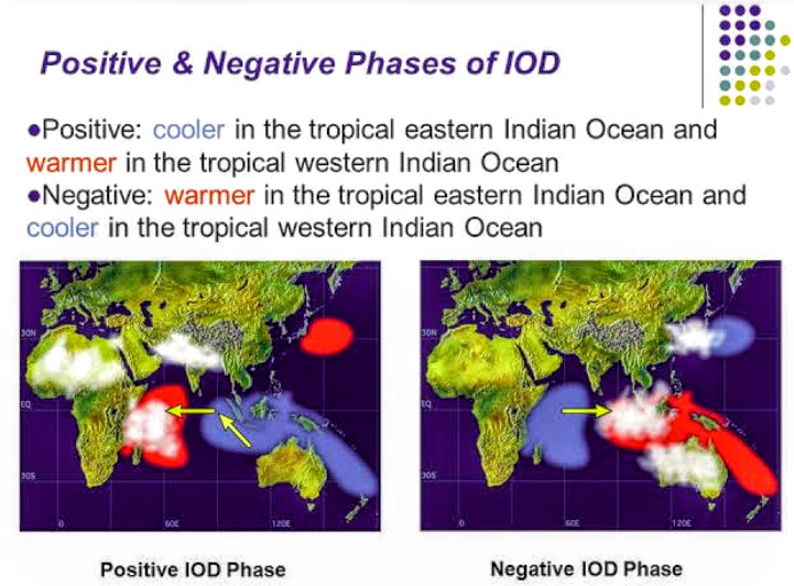
Important dates for disaster preventive measures:
a) Between 26th February, 2020 and 4th March, 2020, (Sever cyclone)
b) Between 9th and 13th March, 2020 and again between 15th and 17th March, 2020,
c) Between 18th March and 25th March, 2020,
d) Between 31st March and 3rd April, 2020, (Cyclone)
e) Between 7th and 9th April, 2020,
f) Between 14th & 16th April, 2020 and again between 21st April & 24th April, 2020 (Severe Cyclone, in the Bay of Bengal/Arabian Sea) and
g) Between 28th April, 2020 and 7th May, 2020.
(3) Moderate Pre-Monsoon rainfall followed by early setting of SOUTH-WEST MONSOON -2020 is forecast between the second week of May and the first week of June, 2020. The Best Rainfall benefits of 2020 Southwest Monsoon will be gained between the first week of May, 2020 and the second week of August, 2020. Two distinctly different weather patterns are forecast (I) From the first week of May till the first week of June, 2020 more widespread rainfall is forecast. (II)Squally winds with Thunderstorms, Induced Cyclonic Circulation, Tropical cyclones and Convective precipitation are forecast from the second week of June till the second week of August, 2020. Heavy to Very Heavy incessant rainfall during the above periods will cause ‘SEVERE FLOODING’. Localised Storms and KILLER LIGHTNING will cause devastations and fatalities during the above periods. From the third week of July till the third week of October, 2020 there will be distinct difference in weather patterns between the first & second fortnight of the months. The first fortnight will experience ‘BETTER’ wet conditions than the second fortnight. I expect 2020 will become the first year to experience more cyclones in a calendar year.
Important dates for disaster preventive measures:
a) Between 9th and 11th May, 2020,
b) Between 13th & 16th May, 2020 and again between 19th & 22nd May, 2020,
c) Between 25th May and 6th June, 2020, Severe cyclones in the Arabian Sea as well in the Bay of Bengal,
In all the above periods (a, b & c) the southern peninsular India, West & Northwest states will get maximum widespread rainfall benefits. Northeast and central Indian states will get moderate benefits.
d) Between 8th & 10th June, 2020 and again between 13th and 15th June, 2020, (Tropical Cyclone)
e) Between 18th June and 22nd June, 2020,
f) Between 27th June and 1st July, 2020, (Tropical cyclone)
In all the above periods (d, e & f) the southern peninsular India, Northeast states will get fairly widespread good rainfall, Central, West and Northwest states will get normal benefits.
Widespread rainfall is forecast for the first fortnight of July, 2020. The southern peninsular India, Northeast states will get more benefits of this widespread rainfall, Central, West and Northwest states will get moderate benefits.
h) Between 3rd July and 6th July, 2020,
i) Look for a Cyclone between 8th July and 20th July, 2020. During this period heavy to very heavy rainfall is forecast between 12th & 14th July, 2020 and the cyclone will cross the Odisha coast around 16th/17th July, 2020.
j) Hot and Dry conditions are forecast between 21st & 31st July, 2020. Isolated locations will get rainfall between 27th July and 31th July, 2020 (Tropical cyclone). This system will cut across central India and expected to move into the Arabian Sea.
k) Another depression related widespread rainfall is forecast between 1st August & 4rh August, 2020,
l) Between 7th August and 15th August, 2020, a new depression in the Arabian Sea will become a Severe Cyclone and expected to cross the North Karnataka/Maharashtra coast.
(4) From the third week of July, 2020 conditions will indicate emergence of “POWERFUL ELNINO”. From the third week of August till the last week of October, 2020 “VERY POWERFUL ELNINO” will be “ACTIVE”. During the above period it will be ‘VERY HOT & DRY’. High activities of Tornadoes, Tropical Cyclones, Trough in Easterlies, Thunderstorms with squally winds & KILLER LIGHTNING and Convective precipitation are forecast during the above period. Isolated places will suffer flooding and damages due to the above conditions. In view of the “EL NINO” factor and the last “Three Underlined Forecast Factor” mentioned in the above paragraph (3), I have to sadly ‘WARN’ that “2020 SOUTHWEST MONSOON will be DEFICIT & SCANTY”. 2020 will be registering WORST MONSOON FAILURE comparable to 2009 MONSOON.
a) Look for a Super Cyclone in the Bay of Bengal/Arabian Sea between 16th August, 2020 and 22nd August, 2020. (Odisha coast and Gujarat/Karachi are likely the locations). Massive Devastations and fatalities are warned at the time of crossing the coast on 22nd August, 2020.
b) Isolated heavy rainfall is forecast between 25th & 27th August, 2020,
c) Between 29th August and 11th September, 2020 look for a Super Cyclone. Between 9th & 11th September, 2020, Heavy to Very heavy rainfall with destructive storms will cause severe flooding and fatalities, Odisha and West Bengal coast could be the location.
d) Isolated heavy rainfall is forecast between 15th & 17th Sept, 2020 and between 23rd & 25th Sept, 2020,
e) Another Depression is forecast between 28th September, 2020 & 8th October, 2020. Massive Devastations & fatalities are warned at the time of crossing the coast around 8th October, 2020. Odisha and West Bengal coast could be the location.
f) Look for another depression between 9th & 11th October, 2020. Heavy to very heavy rainfall at isolated places is forecast during the above period. This depression will become a Severe Cyclone and will cross the coast around 17th October, 2020.
During all the above periods West, Northwest states, interior region of central & southern peninsular states will experience the above weather conditions. East and Northeastern states will remain mostly dry.
(5) 2020 will have “EXCELLENT NORTHEAST MONSOON”. From the last week of October, 2020 till the second week of January, 2021 “Widespread Incessant Rainfall” is forecast. During the above period due to Cyclonic circulations, Tropical Cyclone, thunderstorms with KILLER LIGHTNING will cause FLOODING, LANDSLIDES and DEVASTATIONS upsetting normal life. Also during the above period “More Cyclonic activities are forecast in the Arabian sea”.
Important dates for disaster preventive measures:
a) Between 20th October and 31st October, 2020 look for a Super Cyclone (Bay of Bengal/Arabian Sea) Cyclone in the Bay of Bengal will cross North Andhrapradesh/Odisha coast. “CLOUDBURST” like Very Heavy rainfall is forecast at the time of the Cyclone crossing the coast. Catastrophic damages and fatalities due to cyclonic storm and severe flooding are warned. EastUttarpradesh, Jharkhand, Chhattisgarh and Bihar will also get good rainfall. Cyclone in the Arabian Sea will head towards Arabian Peninsula.
b) Short spell good rainfall is forecast between 3rd & 6th November, 2020, Andhrapradesh and TamilNadu will get the benefits,
c) Look for a Super Tropical Cyclone in the Bay of Bengal as well in the Arabian Sea between 7th & 17th November, 2020. This Cyclone with devastating winds and heavy to Very heavy rainfall will cross the coast of west Bengal/Bangladesh on 16th/17th November, 2020. Catastrophic damages and fatalities due to Very Severe Cyclonic Storm and severe flooding are warned. The cyclone in the Arabian Sea will head towards the gulf of Oman.
d) A new low pressure trough will yield heavy to very heavy rainfall between 21st & 23rd November, 2020 and between 29th November & 3rd December, 2020. TamilNadu, Andhrapradesh, Kerala and Karnataka will get maximum benefits. Flash flooding warned.
‘Severe Winter” will engulf North Indian states between 29th November & 3rd December, 2020.
e) Look for another Super Cyclone in the Bay of Bengal between 5th & 16th December, 2020. This Cyclone with devastating winds and heavy to Very heavy rainfall will cross TamilNadu coast on 15th/16th December, 2020 between Tondi and Karaikal. Catastrophic damages and fatalities due to cyclonic storm and severe flooding are warned.
Between 4th & 15th December, 2020 – Blizzards with heavy to very heavy snowfall/Icy rainfall will upset normal life in Kashmir, Jammu, Ladakh, Himachal Pradesh Uttarakhand, Punjab and Nepal. Severe Warning dates: 8th to 11th December, 2020 and 13th & 15th December, 2020.
f) Moderate rainfall activities with squally winds with thunderstorms are forecast in TamilNadu between 18th & 24th December, 2020 and again between 28th & 31st December, 2020.
g) Look for a cyclone in the Bay of Bengal between 5th & 15th January, 2021. This Cyclone around 14th January, 2021 will cross the TamilNadu coast between Kodikkarai and Cuddalore. Severe damages and fatalities due to cyclonic storm and severe flooding are warned.
 RAMACHANDRAN, Astro-Meteorologist.
sesh.ramachandran@gmail.com https://www.facebook.com/ramachandran.seshadri
Leave a Reply
You must be logged in to post a comment.